
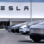
Google is introducing new features for electric vehicles with built in Google Maps. This was announced at the company’s Paris event.
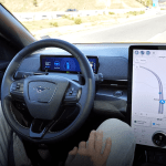
The features aim to reduce range anxiety for EV drivers. Drivers are able to use Maps on their car’s display screen and find nearby charging stations that have chargers of 150 kilowatts or higher capacity for faster charge.
For any journey that will require a stop to charge an EV, Maps will suggest the best stop based on current traffic, EV’s charge level and how much energy the EV can consume.
Maps on EVs will also show when places such as supermarkets have charging stations on-site.
EV drivers are often advised to keep topping up their vehicles whenever they can to ensure a long battery life and avoid driving on a low battery, so it’ll be helpful to know where they can do so as they run errands.
Google said all of the new features for EVs will start rolling out in the next few months. The new Maps features for EVs come three months after Google added filters to the smartphone app for fast charging stations and EV plug compatibility.
Polestar, Volvo, General Motors and Renault are among the automakers that have vehicles with Google built in. At the start of the year, Google said it would roll out a new high-definition version of Maps for cars, starting with the Volvo EX90 and the Polestar 3.
Google also revealed updates to Maps on smartphones during the event, including the expansion of Live View and Indoor Live view, which uses a phone’s camera and augmented reality elements to superimpose directives like arrows and distance markers on top of the real world
Source: TechCrunch


