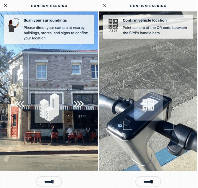
Shared micromobility provider Bird’s new augmented reality parking tool claims to offer a solution to micromobility’s biggest challenges of “providing clearer pavements, more organised parking and better functioning scooter and bike programs.”
Powered by Google’s ARCore Geospatial API, Bird’s Visual Parking System or Bird VPS enables it to geo-localise parked scooters “with pinpoint accuracy” by leveraging years of Google 3D scanning, augmented reality technology and Street View data from around the world.
When parking a scooter, a rider is prompted to take a quick scan of the surrounding area using their smartphone camera and then scan the QR code located on the vehicle.
Using the ARCore Geospatial API, Bird VPS seamlessly compares a rider’s images against Google’s vast knowledge base of data and Street View images in real time. Stationary objects such as buildings and signs are used as reference points, while more dynamic objects like people and vehicles are disregarded.
This near-instantaneous process results in a precise, centimetre-level geolocation, says Bird, enabling it to detect and prevent improper parking with extreme accuracy, helping ensure vehicles are only left in approved areas.
“The new ARCore Geospatial API from Google is an absolute game changer for micromobility that allows us to offer cities a first-of-its-kind parking system that’s unmatched in terms of accuracy and scalability,” said Justin Balthrop, Chief Technology Officer at Bird. “With Bird VPS, we’re able to meet cities’ number one need, proper parking, in a way that’s never been possible before, and we’re able to do it at scale in cities around the world thanks to Google’s robust global data and technology.”
Bird VPS is either already being piloted or will immediately be rolling out in cities including New York City, San Francisco, San Diego, Madrid, Bordeaux and Tel Aviv.


